

Vancouver, British Columbia–(Newsfile Corp. – February 12, 2019) – Cabral Gold Inc. (TSXV: CBR) (OTC Pink: CBGZF) (“Cabral” or the “Company”) is pleased to announce an update of its initial drilling program, as well as assay results from rock chip and auger drilling sampling of the Quebra Bunda target at the Cuiú Cuiú Project, located in the state of Pará, in northern Brazil.
Highlights
- Six diamond drill holes for a total of 549m have now been completed at four different locations at Machichie, the first drill target. Results are pending. Drilling is currently focused on testing the Machichie East Au-Mo-Cu target.
- A composite rock chip sample returned 3,727 g/t Au (119.8 oz/t Au) from a shear zone at the Quebra Bunda target. The result represents the highest-grade sample ever returned from either surface rock chip geochemical sampling or diamond drill programs at Cuiú Cuiú.
- The host structure at Quebra Bunda is 0.5 – 1m wide with an east-west strike. It has now been traced a minimum of 365m along strike to the east and west using saprolite auger gold and pathfinder element geochemistry, and remains open. The high-grade zone is associated with box-worked (after sulphide) quartz veins in the widening segment of the vein.
- The position corresponds to a prominent demagnetized corridor which parallels the trend of Cabral’s MG (Moreira Gomes) deposit, located 1km to the south. The Quebra Bunda target and its structural extensions have not previously been drill-tested, with the nearest historical drilling 1km away.
Drilling update
Six diamond drill holes have so far been completed on the initial high grade Machichie target at Cuiú Cuiú where surface sampling has returned values of 52.5 g/t gold over 0.9m and 23.8 g/t gold over 1.35m. Individual grab samples have returned values up to 356 g/t gold. The targeted structures have never been drill tested.
Of the six holes completed thus far at Machichie, five holes were drilled from three locations over an E-W strike length of 275m to test the central part of the main Machichie structure. One of the five holes was lost at 40.5m depth and a subsequent hole was successfully drilled from the same location.
The sixth hole targeted one of a series of NE trending structures, converging from the SW towards the main E-W trending structure at Machichie, where surface sampling returned values of 19.2 g/t gold.
Laboratory results are pending on all of the above holes. Drilling is currently in progress at the Machichie East target where a significant Cu-Mo-Au anomaly has been identified from a program of shallow auger drilling.
Quebra Bunda target
The Quebra Bunda target is situated 1km to the north of Cabral’s MG resource (Figure 1). It is located in a geological domain adjacent to the NW trending Tocantinzinho Lineament where the Company has recently defined several new high-grade gold targets from rock chip and channel sampling programs[1]. This prospective crustal block is associated with multiple parallel E-W trending structures, marked by corridors of demagnetization in the otherwise strongly magnetic granite basement. These structures are largely concealed beneath soil and transported cover. The artisanal workings locally penetrate the cover sequence and provide useful windows into the basement for sampling.

Figure 1: Location of Quebra Bunda in relation to target areas under evaluation for exploration and resource development in the Cuiú Cuiú Project area
To view an enhanced version of this graphic, please visit:
https://orders.newsfilecorp.com/files/3900/42767_eb934021e4fbebeb_002full.jpg
The Quebra Bunda artisanal working is marked by an area where the modern alluvial drainage has been more intensively processed. It is located on the northern flank of a prominent E-W trending magnetic low (Figure 2). Historical surface soil geochemistry has defined anomalous areas in the range of 50 – 308 ppb Au along the projection of the E-W structure, and along NE-trending structures to the south which converge into the E-W trend (Figure 2). The peak soil anomaly in the vicinity of the Quebra Bunda prospect is 244 ppb Au.
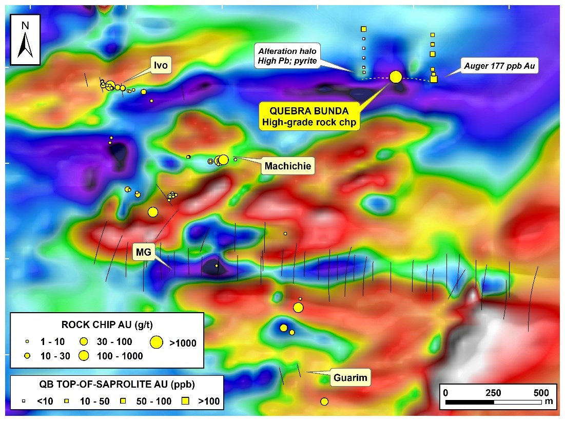
Figure 2: Location of the Quebra Bunda rock chip and auger samples in relation to the E-W demagnetised corridor
To view an enhanced version of this graphic, please visit:
https://orders.newsfilecorp.com/files/3900/42767_eb934021e4fbebeb_003full.jpg
A recent program of auger drilling in the area was designed to test for saprolite gold mineralization along the demagnetized corridor and returned a highly anomalous auger sample result of 177 ppb Au approximately 200m east of the Quebra Bunda prospect. A follow up line of auger sampling 175m to the west, returned anomalous gold colors in panned samples as well as abundant fine pyrite grains suggesting the Quebra Bunda structure extends over a minimum strike extent of 365m and is open to the east and west. The sample was anomalous in lead (a pathfinder element to mineralization) and is interpreted to have intersected the alteration halo of the structure. The auger drilling indicates the presence of a transported palaeovalley sequence covering the structural extensions. The palaeovalley sediments are believed to be subduing the surface geochemical response. The under-cover structural trend is open beyond the limit of auger drilling.
The original alluvial workings date from the 1970’s when gold was worked in the sediments manually by hand panning and sluicing. Recently, the pit was temporarily dewatered by the artisanal miners to access remnant alluvial material, which provided an opportunity for the Company to better access the available exposures of weathered bedrock on the southern side wide wall, where a subvertical shear zone had been identified. Channel sampling in the narrower upper part of the structure indicated the structure was gold-anomalous (0.12 – 0.25 g/t Au). The recognition of any mineralized structure in conjunction with alluvial workings in the Tapajos requires careful evaluation given the discovery history of deposits such as the Palito mine where high-grade structures can taper to have quite subtle surface expressions.
The pit, when dewatered, provided an opportunity to view a better vertical section of the shear. The shear expanded to a width of 1m at depth and contained an increasing abundance of iron-staining and box-worked quartz veins (Figure 3). A composite rock chip sample across this lower part of the vein returned an exceptionally high-grade result of 3,727 g/t Au (119.8 oz/t Au).
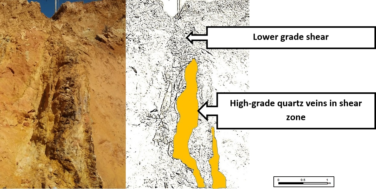
Figure 3: Quebra Bunda E-W shear zone. High-grade mineralization detected in the composite rock chip sample is associated with the zone of box-worked quartz veins outlined in the down-dip sector of structure
To view an enhanced version of this graphic, please visit:
https://orders.newsfilecorp.com/files/3900/42767_4021e4fbebeb_07full.jpg
The east-west trend of the vein trends parallel to the demagnetized zone. The closest drilling along the strike of the trend is located over a kilometer away, to the west at the Ivo prospect. Peak drill results from historical drilling at Ivo included 6.1m @ 3.4 g/t Au, but much of the drilling has been directed into a WNW-trending splay off the main structure. Hole CC_172_12, which traversed part of the magnetic low to the east, displayed strong hematite alteration to the limit of the drilling. The mineralized structures in the district display transitions from hematite to quartz-sericite alteration along and across strike.
Alan Carter, President & CEO commented “We are encouraged by the drilling thus far at Cuiú Cuiú and the initial Machichie target and look forward to receiving the drill results. The recent results from the Quebra Bunda target, which is located 1km north of the Moreira Gomes deposit, also highlight the prospectivity of the E-W structural trends at Cuiú Cuiú and add further credence to the potential for high- grade mineralization associated with prominent E-W trends observed in the geophysical data”.
About Cabral Gold Inc.
The Company is a junior resource company engaged in the identification, exploration and development of mineral properties, with a primary focus on gold properties located in Brazil.
The Company owns the Cuiú Cuiú gold project, which covers the largest of the historical placer gold camps in the Tapajós region of northern Brazil, having yielded an estimated 2MMoz of gold from the overall 20-30MMoz gold produced during the Tapajós gold rush. Placer workings cover over 850ha on the property but are largely exhausted. The few remaining artisanal workers now process gold from palaeo-valley placer deposits and in places exploit high-grade gold mineralization from quartz veins in saprolite (shallow highly weathered bedrock).
In 2018, Cabral reported an updated NI 43-101 Mineral Resource Estimate totalling 5.9MM tonnes grading 0.9 g/t Au (Indicated) and 19.5MM tonnes grading 1.2 g/t Au (Inferred), or 0.2MM ounces and 0.8MM ounces of gold, respectively. That estimate was based on four deposits drilled prior to the cessation of exploration in 2012.
The Company’s current program is designed to improve understanding and expand existing prospects, evaluate newly identified discoveries, prioritize drill targets, and to build upon the existing resource inventory.
FOR FURTHER INFORMATION PLEASE CONTACT:
Alan Carter
President and Chief Executive Officer
Cabral Gold Inc.
Tel: 604.676.5660
Email: info@cabralgold.com
Website: www.cabralgold.com
Dr. Adrian McArthur, B.Sc. Hons, PhD. FAusIMM., a consultant to the Company as well as a Qualified Person as defined by National Instrument 43-101, supervised the preparation of the technical information in this news release.
Neither the TSX Venture Exchange nor its Regulation Services Provider (as such term is defined in the policies of the TSX Venture Exchange) accepts responsibility for the adequacy or accuracy of this release.
Forward-looking Statements
This news release contains certain forward-looking information and forward-looking statements within the meaning of applicable securities legislation (collectively “forward-looking statements”). The use of the words “will”, “expected” and similar expressions are intended to identify forward-looking statements. These statements involve known and unknown risks, uncertainties and other factors that may cause actual results or events to differ materially from those anticipated in such forward-looking statements. Such forward-looking statements should not be unduly relied upon. This news release contains forward-looking statements and assumptions pertaining to the following: strategic plans and future operations, and results of exploration. Actual results achieved may vary from the information provided herein as a result of numerous known and unknown risks and uncertainties and other factors. The Company believes the expectations reflected in those forward-looking statements are reasonable, but no assurance can be given that these expectations will prove to be correct.
Notes
Composite rock chip samples are taken across vein structures along a horizontal level to produce a samples typically 3 – 5 kg in weight, and are taken where rock competency or access constraints prevent the channel sampling technique with a trenching tool. Samples are sent to SGS for preparation (method code PRP102_E – crushing to 3mm, quartering, and pulverising to produce a 250-300g pulp with 95% passing 150 mesh). Gold analysis has been conducted by SGS method FAA505 (fire assay of 50g charge). The high grade sample was checked by FAA525 (reported value). Analytical quality is monitored by certified references and blanks. Until dispatch, samples are stored under the supervision the Company’s exploration office. The samples are couriered to the assay laboratory using a commercial contractor. Pulps are returned to the Company and archived. Under the agreement with the Cuiú Cuiú condominium, local artisanal operators can process mineralization to a depth of 30m, unless otherwise negotiated. Historical drilling results are reported as down-hole length weighted intersections unless otherwise stated.
[1] See Cabral Press releases dated March 21, 2018, June 19, 2018 and July 19, 2018